


Introduction: When Noise Pretends to Be Evidence
Every modern conflict now has two battlefields.
One is physical. The other is digital—and far louder.
In the aftermath of the latest India-Pakistan escalation, social media platforms were flooded with claims that Pakistan’s nuclear assets were struck at Kirana Hills, triggering alleged radiation leaks and forcing U.S. nuclear emergency intervention. Screenshots replaced sensors. Tweets replaced treaties. And speculation replaced physics.
This article does not argue patriotism.
It argues process, doctrine, and evidence.
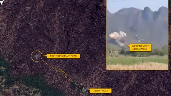
What Kirana Hills Are—and What They Are Not
Kirana Hills are a low-lying rocky outcrop near Sargodha—geographically modest and long mythologized online.
What matters:
-
Nuclear facilities are never identified via Google Maps pins
-
Locations of strategic assets are deliberately compartmentalized
-
Pakistan and India exchange nuclear site lists annually, including in January 2026
Even Indian commentators themselves acknowledged:
“No one knows the exact locations of Pakistan’s nuclear installations.”
That single admission collapses the entire “Google Maps = nuke site” theory.
The BE-350 ‘Radiation Aircraft’ Claim: A Forensic Debunk
The most viral claim asserted that a U.S. Department of Energy nuclear emergency aircraft had landed in Pakistan to assess radiation leaks.
The aircraft cited: Beechcraft BE-350, registration N111SZ.


Here is the verifiable record:
-
Originally operated by the United States Department of Energy
-
Decommissioned in 2010
-
Sold, re-registered, and transferred
-
Operating with Pakistan Army Aviation since 2011
-
Routinely flies inside Pakistan, including training and liaison sorties
The aircraft did not arrive in response to an emergency.
It never left Pakistan because of one.
If a real radiological incident had occurred:


Mujtaba
January 17, 2026 at 5:16 pm
This is a world class analysis.