


































Share the post “Modi’s Tashkent Detour Exposes the Price India Pays to Bypass Pakistan”
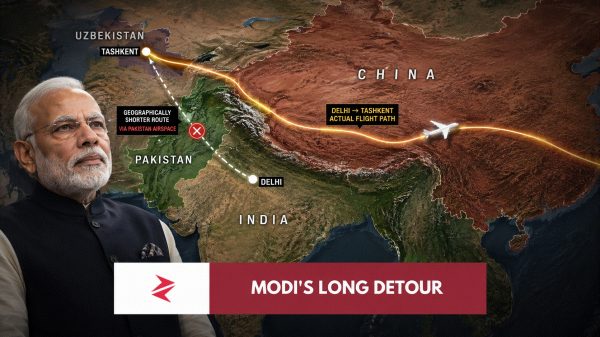
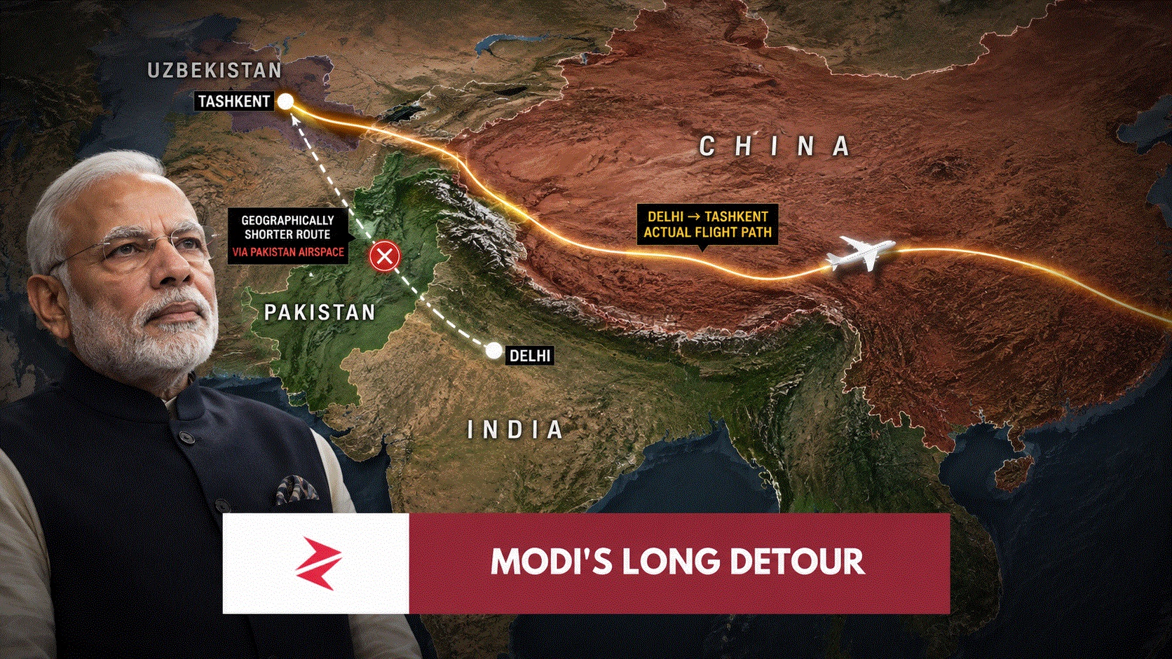
Sometimes geography delivers an argument more brutally than diplomats ever can. India can call Pakistan irrelevant, economically insignificant, strategically avoidable or whatever the latest television-studio vocabulary demands, but when the aircraft carrying the Indian prime minister has to leave Delhi, turn east, travel across a substantial arc of Chinese territory and then work its way back toward Central Asia because Pakistani airspace is unavailable, the map itself starts answering the propaganda.
Narendra Modi did reach Tashkent. India was not “trapped.” China did not close its skies to him. Modern aviation is perfectly capable of constructing alternative routes. All of those things are true.
What is equally true—and considerably more interesting—is that the alternative was visibly longer precisely because Pakistan occupies geography India cannot wish away.
Hindustan Times, hardly a Pakistani propaganda outlet, reported that Modi’s special aircraft “took a longer route through Chinese airspace since Pakistani airspace remains closed to Indian aircraft.” Uzbekistan’s presidency separately confirmed Modi arrived in Tashkent on August 29 for his state visit, while India’s own Prime Minister’s Office confirmed that Uzbekistan and Kyrgyzstan were the destinations of his August 29–September 1 Central Asian tour.
That is the fact. The viral mockery came afterward.
And beneath all the memes is a serious strategic lesson India has spent years pretending does not exist.
First, the viral “8.5 hours” claim needs separating from what is actually verified
Screenshots circulating on X and FlightRadar-style maps show the aircraft making an extraordinary eastward sweep through China before turning northwest toward Tashkent, and several viral posts describe what would ordinarily be roughly a two-and-a-half-hour journey as taking around eight or more hours.
The strongest independent reporting I can verify confirms the longer Chinese route and explicitly attributes it to the Pakistani airspace restriction. It does not independently establish every “8.5 hours” or “13 hours” figure being circulated on social media. That distinction matters because a good Pakistani argument does not need an exaggerated number when the documented fact is already devastating enough.
Pakistan’s current restriction is real, formal and continuing. The Pakistan Airports Authority extended the ban through September 24, 2026, with its NOTAM stating that Pakistani airspace is unavailable to Indian-registered aircraft and aircraft operated or leased by Indian airlines and operators, including military flights. The restriction applies across both the Karachi and Lahore Flight Information Regions.
So the central claim survives verification intact: Modi’s aircraft took the longer Chinese route because the Pakistani corridor was unavailable.


That is not a meme. It is aviation geography.
“Why didn’t he just fly over Ladakh, Tibet or the Himalayas?”
This became the most interesting question underneath the screenshots because, on a flat map, the supposed answer looks embarrassingly obvious. Delhi is south of the Himalayas. Tashkent is northwest. Why not simply draw a diagonal line over Ladakh and Tibet?
Because aircraft do not navigate international airspace like somebody dragging a finger across Google Maps.
Civil and state aircraft operate through planned airway structures, sovereign permissions, air-traffic-control sectors, terrain-clearance requirements, contingency planning and emergency escape routes. ICAO material discussing routes north of the Himalayas specifically notes constraints involving aircraft oxygen capability, escape routes and Chinese air-traffic-management capability in remote airspace. That is considerably more authoritative than the social-media claim that “planes simply cannot cross the Himalayas”—because they can. The issue is whether a particular route is operationally sensible, authorised and adequately protected against contingencies.
The biggest problem appears if cabin pressurisation is lost. Over ordinary terrain, an aircraft can rapidly descend toward an altitude where supplemental oxygen is no longer required. Over very high mountainous terrain, the mountains themselves can prevent that descent. IATA explicitly identifies this as an operational consideration: aircraft traversing high terrain must carry enough crew and passenger oxygen for the longer time required to reach a safe altitude after decompression.
The Tibetan Plateau adds another complication. Its average elevation is around 4,500 metres, while emergency landing options and lower terrain are sparse. Aircraft certainly fly within and across parts of this region, but airlines generally do not treat the plateau as an unrestricted shortcut where one simply draws the geometrically shortest line between Delhi and Tashkent.
So “why not just go over the Himalayas?” is the wrong question.
The better question is why India’s most straightforward westward aviation geography runs through Pakistan in the first place.
And that answer is uncomfortable for anyone selling the fantasy that Pakistan can simply be erased from India’s strategic calculations.